USask hydrology courses spark interest from around the world
When Dr. Nicholas J. Kinar (PhD) tweeted about the online hydrology class he’s teaching at the University of Saskatchewan (USask) this fall, he didn’t know it would attract international attention.<br/><br/>
By Shannon BoklaschukAfter Kinar made his Twitter post on Aug. 20, people from around the world—including Canada, the U.S., India, Nepal, Chile, Indonesia, and Nigeria—contacted him about the course, which he has designed with an innovative and interactive remote-learning experience in mind.
Most USask classes will be taught remotely this fall due to the global COVID-19 pandemic. Although the pandemic has impacted many aspects of university life, Kinar has a positive attitude and is excited about the online learning that will take place in Advanced Hydrology (Geography 427).
“I see the glass as half full rather than half empty,” said Kinar, a Global Water Futures research scientist and the assistant director of the Smart Water Systems Lab.
“I look at it this way: It’s a positive time because we’re able to come together and we’re able to do important and interesting things.”
While it’s too late for students from outside of USask to register for the Advanced Hydrology course—which is being offered through the Department of Geography and Planning in USask’s College of Arts and Science—Kinar will still make the class materials as accessible as possible for a global audience. For example, he plans to livestream the virtual field trip scheduled for Sept. 22 to the St. Denis National Wildlife Area.
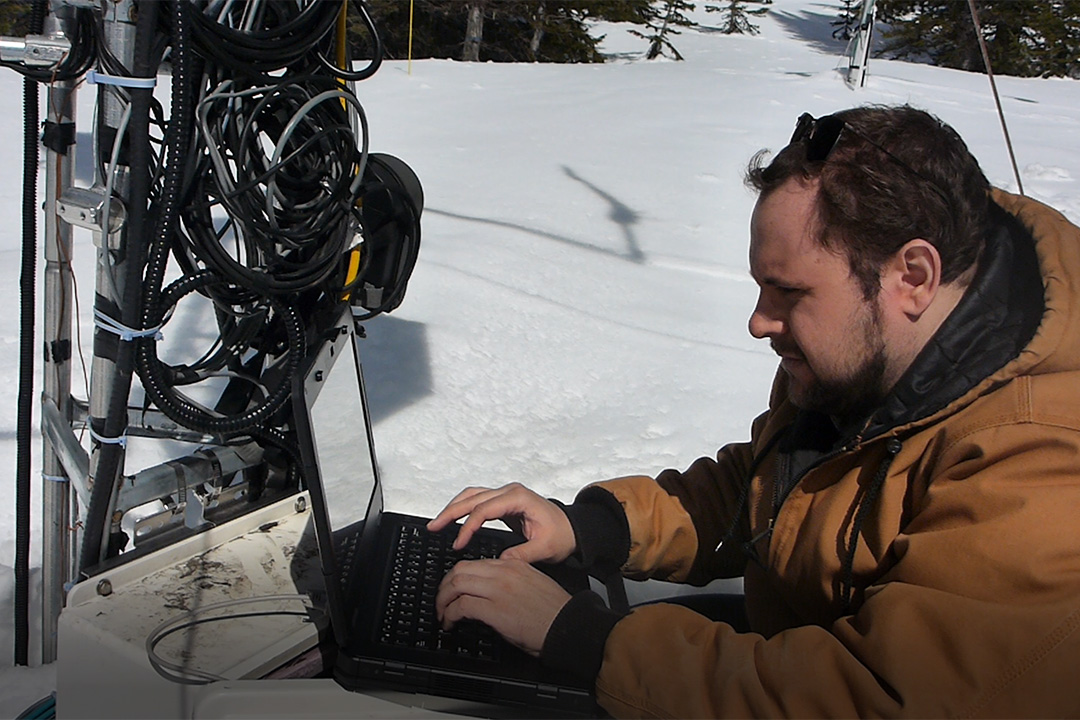
“I have this livestream set up, where it will be over cellular networks,” he said. “I have a hardware encoder and two cameras—one is a 360-degree camera where you have two separate lenses. If you have a 360-degree view, people watching this on YouTube can actually see a 360-degree view of the field site.”
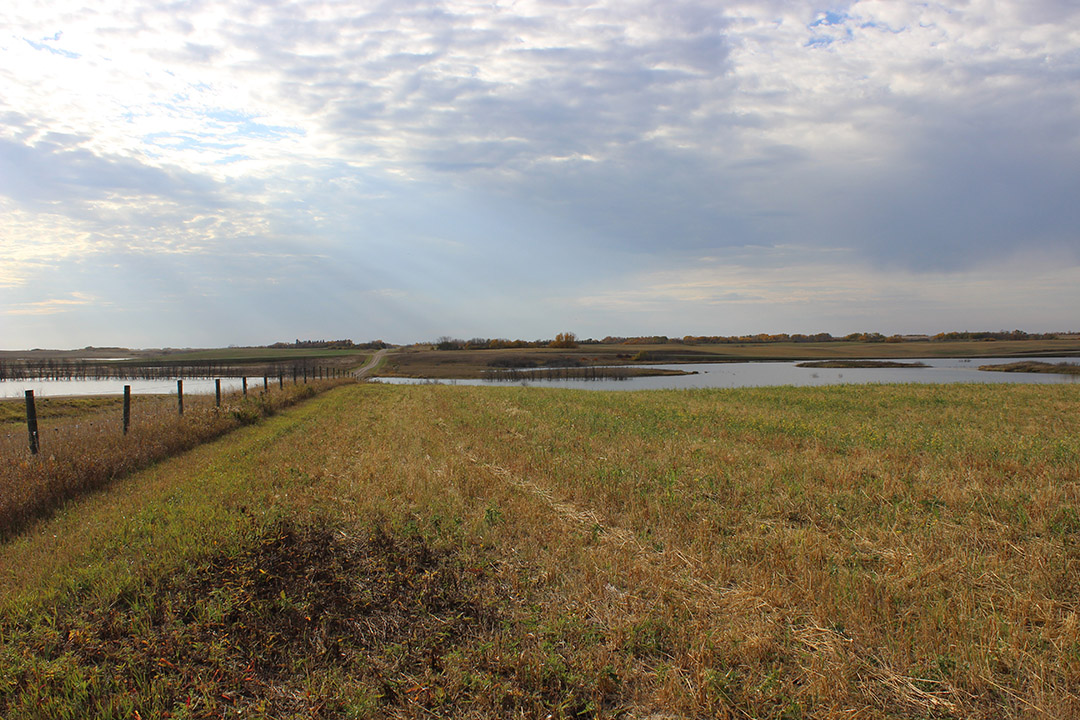
St. Denis National Wildlife Area is a watershed situated east of Saskatoon underlain by low-permeability glacial tills with some sand deposits. The watershed has been extensively monitored by Environment Canada for decades and is the location of numerous interdisciplinary studies related to the biology and hydrology of the area, said Kinar, noting “meteorological, snow, groundwater, and water-level measurements have been extensively made at this site, along with air photography, remote sensing, and careful visual observations.”
Kinar said the large amount of data collected at the St. Denis National Wildlife Area since the 1960s “has allowed for numerous breakthroughs with respect to advancing our understanding of semi-arid Canadian prairie hydrology,” leading to the development of new physical models of environmental phenomena related to runoff, drought prediction, and water availability.
The livestream is a “win-win situation,” said Kinar, since people from outside of USask will be able to watch the field trip in real time on YouTube, while the USask students in his class will be able to interact with him and another field trip guide through Webex. An instructor at the University of Wisconsin-Milwaukee is also planning to use the field trip as part of his class syllabus, meaning the students at that university will watch the livestream or a recording of the livestream as part of their class.
On the day of the field trip, the 360-degree camera livestream will be able to be viewed at this link, while the 2D camera main stream can be viewed at this link.
“It’s going to be really interesting,” Kinar said.
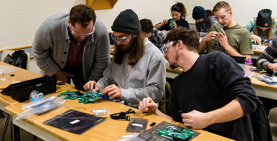
In addition to the virtual field trip, there are other unique aspects to Kinar’s online class; for example, he will provide students with custom electronic circuits to enable them to measure and interpret environmental data. Kinar first designed the circuit boards and built them with his students last year, and later wrote a journal article about the results. The article is currently under review by Geoscience Communication, an interactive open-access journal of the European Geosciences Union.
Kinar’s latest circuits, to be used in the fall course, are currently being built by a contract manufacturer and will be shipped to the students when they’re ready. The custom circuit boards will measure radiation, relative humidity, and temperature, and then log the data to SD cards. A Wi-Fi module on the circuit boards will enable the data to be uploaded to a server and entered into a spreadsheet so that students can run mathematical models of hydrological phenomena.
“If you have these different components, essentially what you can do is you can run an energy-balance model for snow melt,” he said. “You can understand exactly how much water will leave the surface of the Earth in terms of evaporation or evapotranspiration.”
Another interesting aspect of Kinar’s course is that students will create their own models of watersheds that will be printed on a 3D printer. It’s been a tradition in Kinar’s class for about six years for students to access a free and open-source geographical information system (GIS) software package and find map data or raster datasets of mountains or other geographic features.
“The idea behind the assignment is to download the data and to use a computer algorithm to be able to delineate a watershed,” said Kinar. “A watershed is an area of the land’s surface where all the water generally flows toward a stream and drains to a common outlet. What’s really neat about this is there are algorithms to be able to delineate the watershed. Once this area of the land’s surface is converted to a file—a GeoTIFF file—I’ll use a computer program to convert the file into a three-dimensional representation. It’s really incredible, because once this is printed on a 3D printer you can literally see where all the river channels are and all of the sub-basins—and you can actually literally trace with your hand where water will flow over the land’s surface.”
Like Advanced Hydrology, Geography 825—another course offered this fall by the Department of Geography and Planning—will focus on hydrological modelling. Another similarity is that the graduate-level Process-Based Hydrological Modelling Course, taught by Dr. Martyn P. Clark (PhD) through USask’s Centre for Hydrology, has also attracted international attention. Because of the flexibility inherent in the online-learning model, students from the Canadian government, many Canadian universities, and from various locations around the world—including Europe, India, and the U.S.—have enrolled in Clark’s class.
Clark’s course was originally intended to be a two-week in-person intensive experience in the Canadian Rockies, but the COVID-19 pandemic necessitated the move to a remote-learning format. That change “really opened things up for people who wouldn’t have been able to take it otherwise,” said Clark, a faculty member in the Department of Geography and Planning and associate director of the Centre for Hydrology.
“I was getting a lot more (interest from) people from Europe, because they can take it without having to travel, and a lot of people from the Canadian government, who wouldn’t be able to take two weeks off to take a course,” he said. “So it really opened things up. People were getting excited about it.”
Clark’s course is focused on the “inner workings” of hydrological models and understanding the assumptions that are being made as well as the uncertainties. For the past 20 years it’s been a research focus of Clark, a world-renowned expert in the area. He received support from the Pacific Institute for the Mathematical Sciences (PIMS) to develop the quantitative exercises used in the course.
While moving his course online has been a challenge, Clark believes it will ultimately work out “quite well.” The learning exercises in the class have been designed so that people from different parts of the world can work together, helping them to build relationships online.
In some ways, Clark said, the online course could prove to be a better experience than the previously planned in-person course, since students from various countries will bring their unique perspectives and experiences to the virtual classroom.
“I still hope it’s going to be a community-building experience,” he said.
Article re-posted on .
View original article.