Overview
![]()
The Smart Water Systems Laboratory is a Centre for Hydrology facility housed within the National Hydrology Research Centre in collaboration with the Global Institute for Water Security. The following have made significant contributions to the laboratory.
- Western Economic Diversification Canada
- Environment and Climate Change Canada
- Canada Foundation for Innovation
- Natural Sciences and Engineering Research Council of Canada
Capabilities
- Data Collection (UAV/Sensors)
- Data Processing and Storage
- Electronics Research, Design and Production
- 3d Printing and Scanning
- Multiple workstations for students and researchers
Capacities
- Improved measurements for predicting water quality and quantity
- Increased support for forecasting the threat of disaster from floods and droughts
- Information for communities and industries to reduce and manage their flood risk
- Information for farmers and ranchers to manage drought impacts on agriculture
- New environmental technologies for sustainable development in Canada
The SWSL has multiple workstations and tremendous electronic facilities for sensor design research. The lab supports the deployment of airborne drones equipped with sophisticated sensors for mapping and diagnosis of land surface processes. Novel ground-based sensors support environmental monitoring and hydrological process studies. These sensors include UAV-based and terrestrial LiDAR, Multispectral, Hyperspectral, Optical, Thermal and IR imaging radiometers, Field spectrometer and traditional survey equipment.
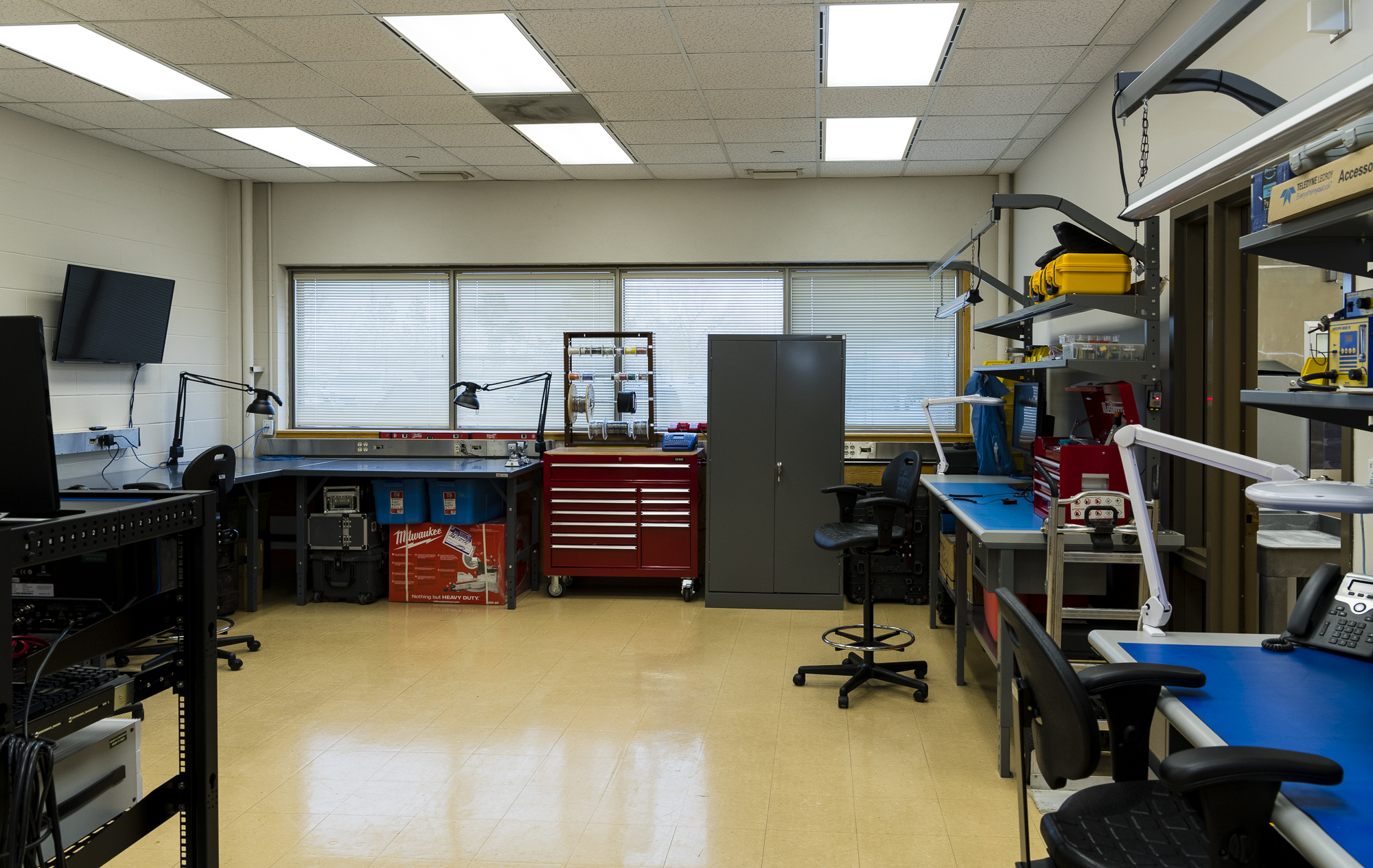
Lab Equipment
- 3 Permanent workstations (Students, Researchers and Scientists)
- Novatel Base station (roof mounted continuous operation) (PwrPak7)
- Stratasys 3d Printer (Model F370)
- Portable 3d scanners (Artec 3D Spider and Eva models)
- Espec Environmental Chamber
- Custom Computer and Server systems
- Portable diagnostic electronics station
- Reflow Oven and Stencil printer
- Virtual Reality (VR) devices (x3)
Latest News
Recent Papers:
Measurement of Terrestrial Snow Nicolas J. Kinar, John W. Pomeroy
Signal processing for in situ detection of effective heat pulse probe spacing radius as the basis of a self-calibrating heat pulse probe N. Kinar, J. Pomeroy, B. Si
Recent News:
Canada Water Agency will help protect and sustain Canada’s water resources: USask water scientists
Water Towers Threatened, John Pomeroy
Science & Research
Field Research Site Locations
| Location | KML | Coordinates |
| Clavet, Saskatchewan | Google Maps | 51°, 56', 25.2816" N, 106°, 22', 47.0712" W |
| Rosthern, Saskatchewan | Google Maps | 52°, 41', 45.6612" N, 106°, 27', 42.1569" W |
| Peyto Glacier, Alberta | Google Maps | 51°, 41', 1.1561" N, 116°, 32', 36.2469" W |
| Marmot Creek Research Basin, Alberta | Google Maps | 50°, 57', 21.4812" N, 115°, 10'53.8644" W |
| Fortress Mountain Research Basin, Alberta | Google Maps | 50°, 50', 8.8116" N, 115°, 13', 22.9044" W |
| Wolf Creek, Yukon Territory | Google Maps | 60°, 31', 40" N, 135°, 31', 14" W |
| Forêt Montmorency, Quebec | Google Maps | 47°, 19', 20.1" N, 71°, 08', 49.6" W |
| Boreal Ecosystem Research and Monitoring Sites (BERMS) Old Jack Pine Site, Saskatchewan | Google Maps | 53° 54' 57.6" N, 104° 41' 31.2" W |
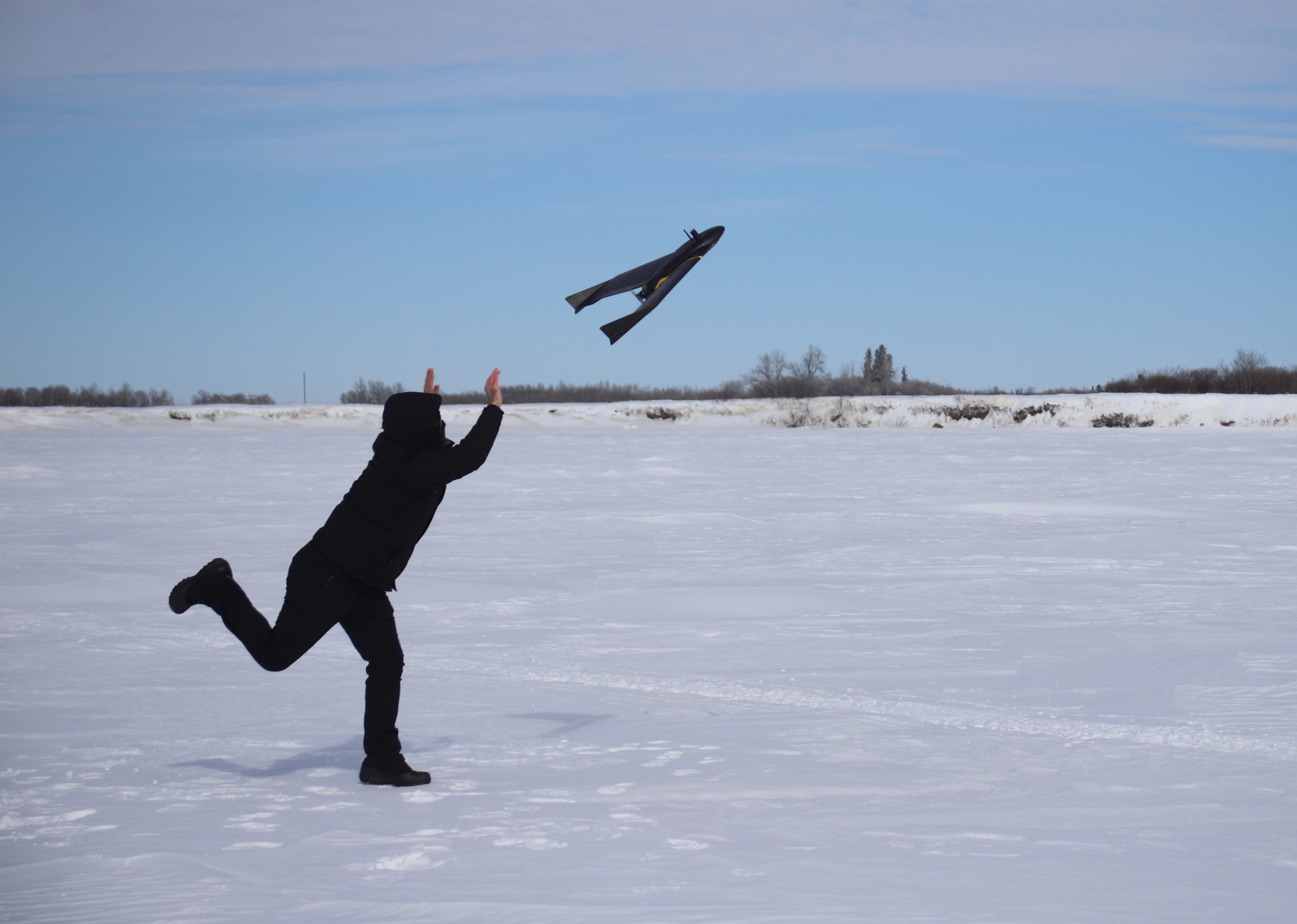
A number of UAVs are available for mapping of landscapes during the snow-covered and snow-free seasons. The UAVs owned and operated by the SWSL are deployed at field sites in the Prairies and Rocky Mountains. UAV platforms manufactured and configured by DJI International, Sensefly, DraganFly and Freefly systems are available for use in research projects.
SWSL Drones and Associated Sensors
| Drone | Sensor(s) | Sensor Description | Wavelength |
| DJI M600 Pro | Riegl Mini Vux-1, Sony RGB | Lidar Mapping unit with Integrated Sony 24mp camera | 905nm, 380nm-740nm |
| DJI M600 Pro | Corning Hyperspectral Camera | Push-broom Line Imaging Spectrometer | 400nm – 1000nm |
| DJI Mavic 2 Pro | RGB camera | Hasselblad 20mp camera | 400nm-700nm |
| eBee RTK | Soda | Aerial RGB Photogrammetry camera | 380nm-740nm |
| eBee X | 3D Soda, Duet T and S110 NIR | Gimbal Aerial RGB Photogrammetry camera, Dual Aerial RGB Photgrammetry camera and thermal mapping camera / 12mp Canon near infrared (NIR) band camera | 380nm-740nm, 7.5µm – 12.5µm, G-550nm R-625nm NIR- 850nm |
| eBee X | Duet T | Dual Aerial RGB Photogrammetry camera and thermal mapping camera | 7.5µm – 12.5µm |
| Draganfly Commander | RGB, FLIR | 20mp Aerial Camera paired with a FLIR long wave infrared camera | 380nm-740nm, 7.5µm – 12.5µm |
| ALTA X | Riegl MiniVux-2UAV/ Sony Alpha 7RIII /TetraCam Multispectral with thermal Camera | Lidar Mapping unit with Integrated Sony 42mp camera and a Multispectral 6 narrow band camera array with thermal camera option | 905nm, 380nm-740nm/450nm – 1000nm / 7.5 µm to 13.5 µm |
| ALTA X | Medusa Gamma Ray MS1000 | UAV Gamma Ray detection system |
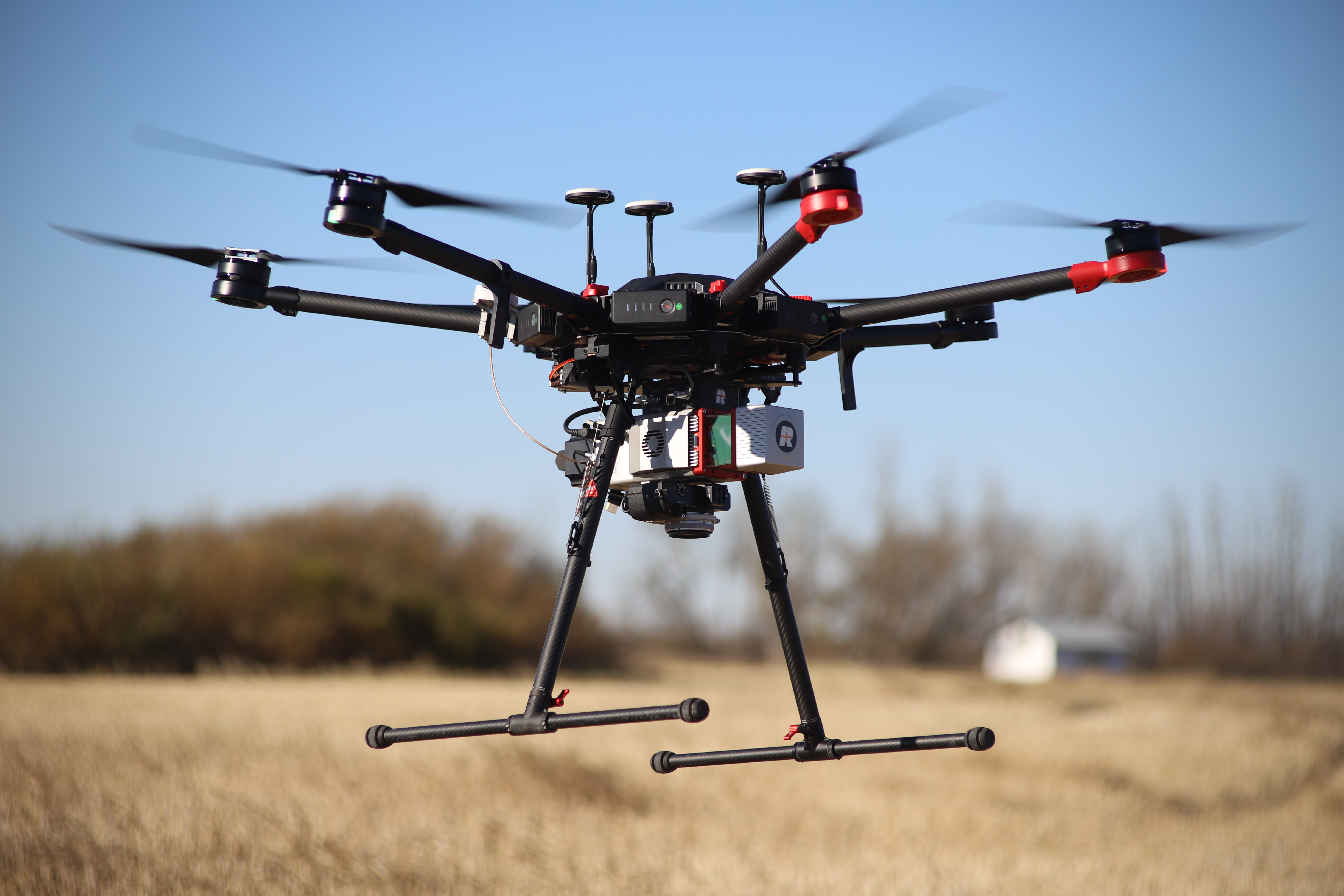
DJI m600 with Riegl MiniVux1
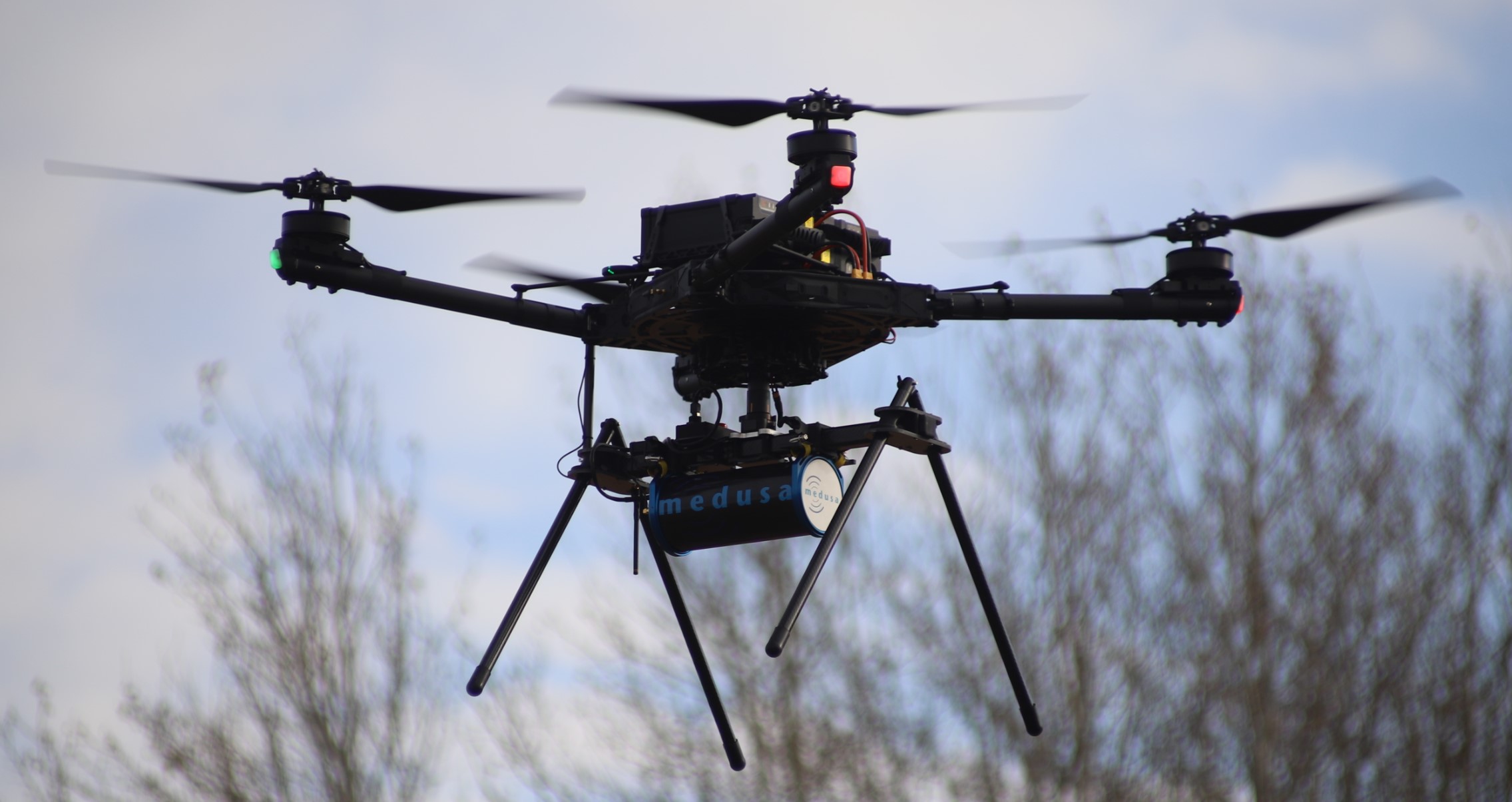
ALTA X with M1000 Medusa Gamma Ray Spectrometer
eBee X with Duet T
Personnel
Personnel
Core Research Personnel
- Dr. John W. Pomeroy, Director SWSL
- Dr. Alain Pietroniro, Environmental Remote Sensing
- Alistair Wallace, SWSL Manager / Lidar Specialist / Remote Sensing
- Lindsey Langs, (Canmore)
- Hannah Koslowsky, (Canmore)
- Kieran Lehan, (Canmore)
Associated Faculty
- Dr. Markus Brinkmann
- Dr. Colin Whitfield
- Dr. Bing Si
- Dr. Rich Petrone
- Dr. Helen Baulch
- Dr. Cherie Westbrook
Links

![]()

![]()